The lakebed revealed
Great Salt Lake has lost over half its surface area and eleven feet of elevation. Nearly a thousand square miles of lakebed are now dry, and the decline continues unabated. The vanishing Great Salt Lake creates two imminent ecological calamities. The first is the collapse of a globally important ecosystem supporting ten million birds. The second is toxic dust from the dry lakebed becoming airborne in dust storms. This collection shows views of Great Salt Lake and its deadly lakebed.

In 2021, after twenty years of steady decline, the Great Salt Lake reached its lowest levels in recorded history, and continued to set a new record low each day for the next 95 days. Because the lake is so shallow, each inch of water lost translates to miles of lost surface area and bird habitat.

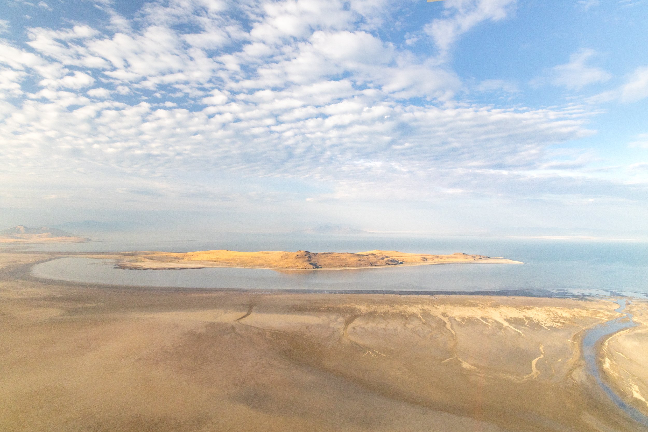
Great Salt Lake's largest tributary, the Bear River, no longer makes it into Great Salt Lake. This is an aerial view of Bear River Bay of Great Salt Lake looking north. The Bear River can be seen in the center of the photo as it disappears into the dry lakebed.
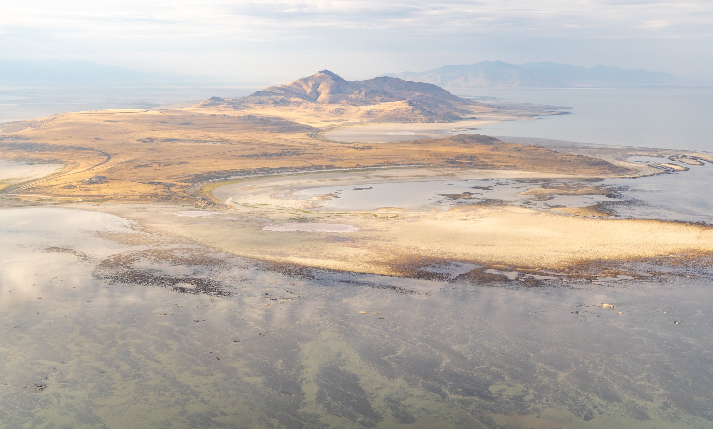
Dry lakebed advances toward Fremont Island in Great Salt Lake. A land bridge connecting the island to the shore can be seen on the left of the image.

Mineral extraction industries cover large sections of the lakebed in Bear River Bay. A causeway separates Bear River Bay from the rest of the lake. Bear River no longer reaches the causeway.

Antelope Island from an airplane showing microbialites both exposed and submerged under shallow water (foreground).
Antelope Island from an airplane showing microbialites both exposed and submerged under shallow water (foreground).

Dry lakebed of Great Salt Lake as seen from the Antelope Island looking north toward Bear River Bay. Large areas of the lakebed are heavily saturated with toxic materials and situated close to major population centers.

A California Gull flies over a dry section of Great Salt Lake in mid-July, 2022. In the distance can be seen Fremont Island, now no longer an island since it is now half surrounded by cracked mud. The zig-zag line in the mud in the foreground was the waterline as recently as June.

Shorebirds and gulls pack into drying puddles in the almost entirely dry Farmington Bay of Great Salt Lake. Farmington Bay is now almost completely cut off from the main body of the lake, with only an intermittent trickle of water flowing from Farmington Bay to the main body of the lake. This will impact salinity and nutrient levels in both areas.

Great Salt Lake dry lakebed. The sediments of the lakebed contain high concentrations of heavy metals such as arsenic and mercury from industrial activities, agricultural runoff, sewage, and natural sources. These toxins can become airborne in dust storms and threaten human health as well as soil, air, and water quality across Utah and neighboring states.

A California Gull flies over the Great Salt Lake dry lakebed as seen from the Antelope Island Causeway looking North toward Fremont Island and Bear River Bay.

A pool of water from the receding Great Salt Lake is trapped in the contours of the microbialite reef. As the water in these pools dries up, salinity increases, favoring a population of extreme halophilic microbes that are orange to pink in color. At these extreme high salt concentrations, the lake's two invertebrate species, brine flies and brine shrimp, do not survive for long.

Beyond cracked mud. Great Salt Lake contains the world's largest population of living microbialites, a photosynthetic reef-like structure on the lakebed underpinning the lake's food chain. Low water at Great Salt Lake has exposed most of the lake's ancient microbialites, leading to bleaching and erosion.

A California gull skirts an exposed microbialite reef in Great Salt Lake at sunset. The dark material in the middle distance is microbialite reef, exposed when the lake hit its lowest recorded levels in summer of 2021. The lake is expected to lose another two feet of water in summer of 2022, threatening nearly all of its remaining microbialites.